Green Country Forecast: Isolated Storms Linger as Heat and Humidity Rise

A mid-level disturbance moving from northeast Texas across southeastern Oklahoma will continue to result in a few scattered showers and storms across southeastern Oklahoma into western Arkansas. Combined with tropical moisture, heavy downpours would be likely for these areas.
Tulsa Metro Weather Outlook
Regarding the Tulsa metro, a slight chance for a pop-up shower or storm will continue today, with higher chances to the south and east. A few scattered storms are likely to develop today with afternoon heating but probabilities remain limited and mostly near or less than 20% for most locations.
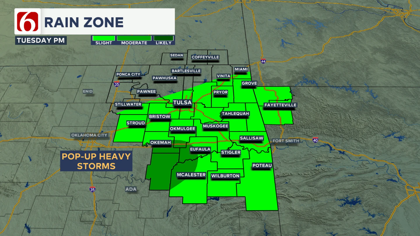
A slightly better chance for a few showers or storms will be from 3 PM today until 9 PM tonight along the I-40 corridor region. Temperatures will climb into the lower 90s and combine with tropical moisture.
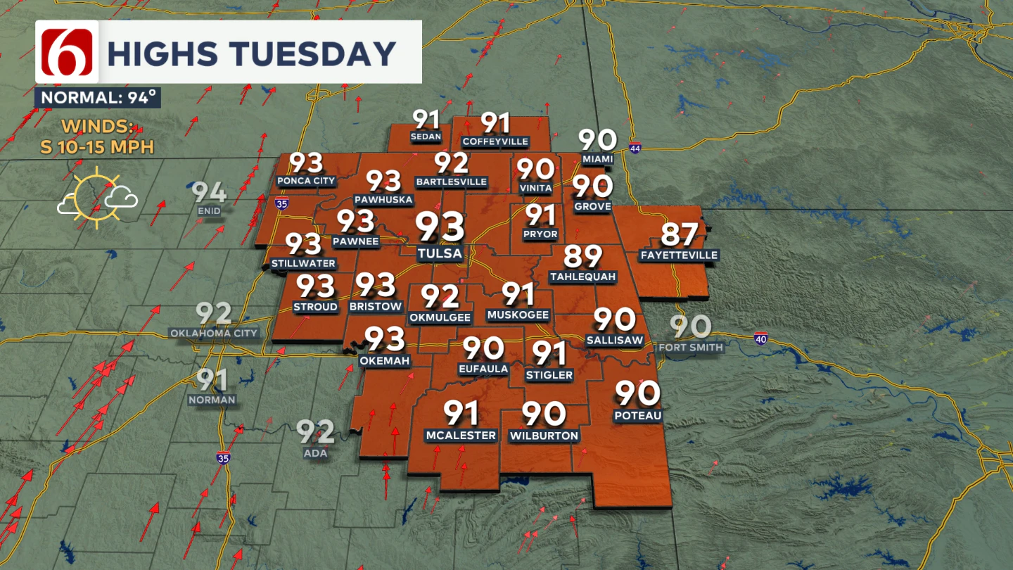
Heat index values will reach or exceed 100° in many locations, possibly as high as 104° this afternoon. South to southwest winds will increase slightly to 10 to 15 mph with some higher gusts.
Any Wednesday Showers?
A slight mention for a shower or storm will be continued for Wednesday, but probabilities will remain only near 10%. Wednesday morning lows in the 70s bring daytime highs in the lower to mid-90s.
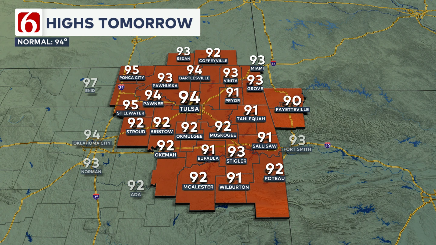
Additional heat stress will continue to grow, with heat index values above 100° to near 105° on Wednesday.
Midweek Update
Thursday, a strong storm system will move across the Rockies into the northern High Plains states, where showers and storms will become more numerous.
This system will help push a weak front southward, approaching southern Kansas, southwest Missouri, and northern Oklahoma on Thursday or Thursday evening.
At the same time, a mid-level ridge of pressure currently west of the area will expand eastward and should begin influencing our weather.
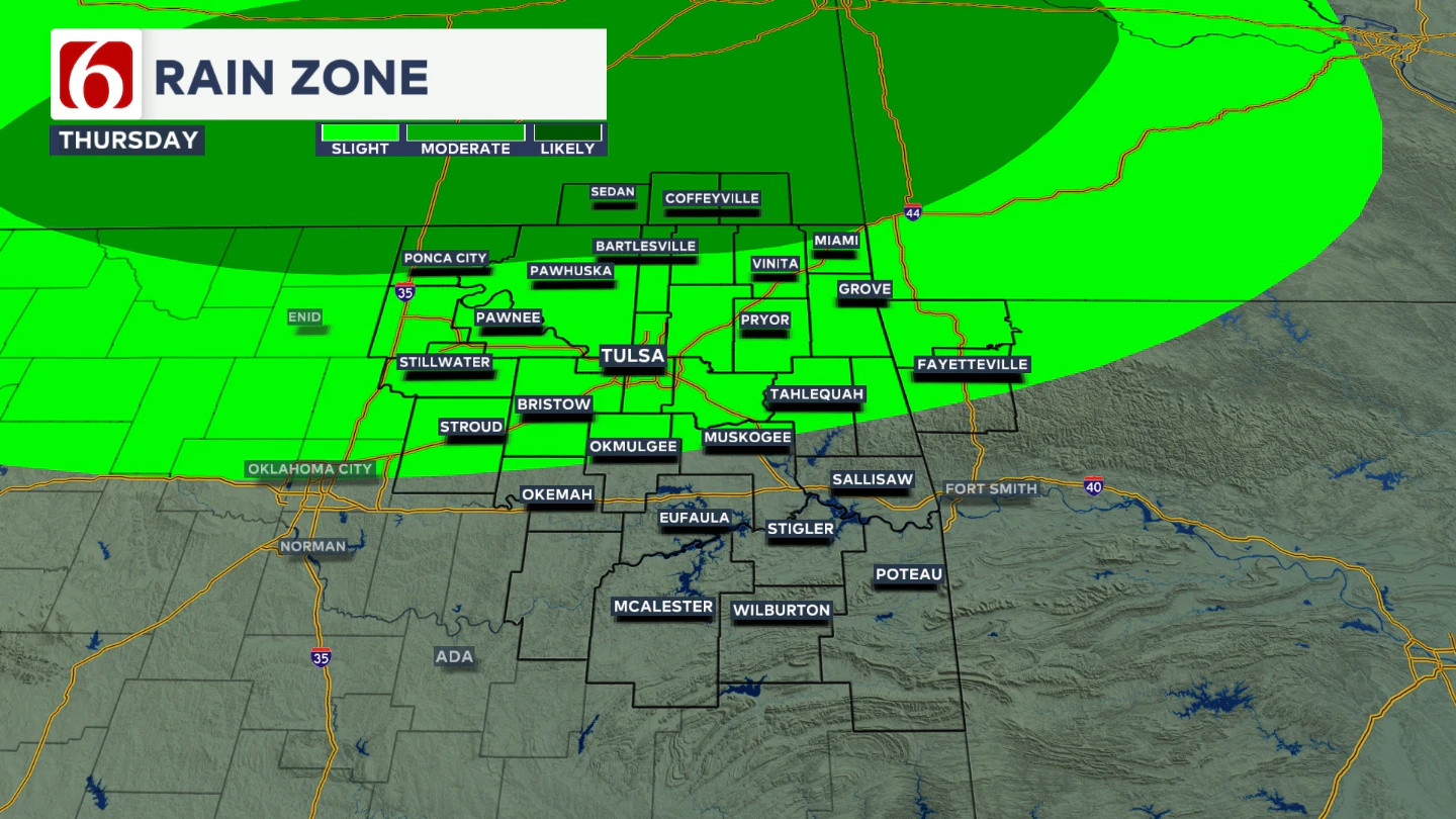
This means the probability of the front moving southward remains low, but an outflow boundary may approach and bring a few showers or storms near the area Thursday, especially Thursday night or early Friday.
Higher probabilities will be confined to far northern Oklahoma and southern Kansas.
Hot and Humid Weekend Ahead
By the weekend, the ridge should strengthen and keep shower and storm chances away from the area. This will also bring an increase in heat and humidity.
Morning lows will be in the mid-70s, with daytime highs climbing into the mid or upper 90s.
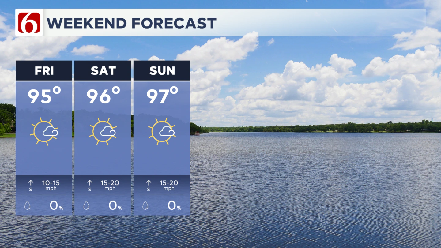
The combination of transpiration rates and low-level moisture will result in heat stress. Heat advisories are likely as values meet criteria, with heat index readings climbing from 104 to near 108° this weekend.
Lake Levels
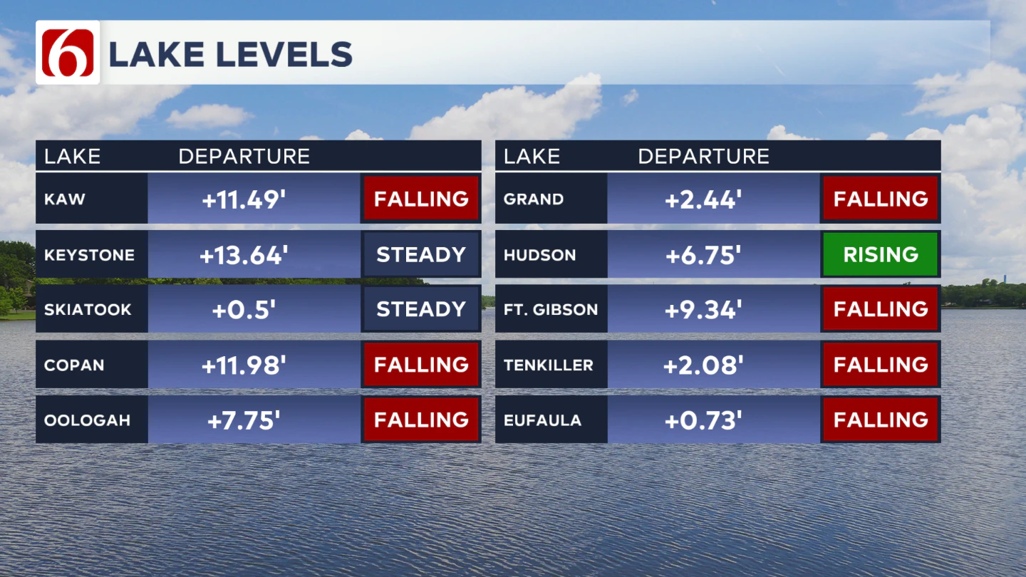
Area lake levels remain high but are slowly improving. Check ahead as high water levels may impact some recreational areas.
The Morning Weather Podcast:
The daily morning weather podcast briefing will remain on hold indefinitely due to ongoing internal workflow issues.
We're working to resolve these challenges as soon as possible and appreciate your patience. We apologize for the inconvenience and hope to be back soon. Thank you for your understanding.
Hot weather safety:
🔗Oklahoma heat safety tips: How to spot and prevent heat illness
🔗 Top summer safety tips every family needs to know
🔗 Swimming pools, splash pads & aquatic centers in Tulsa metro to stay cool
Need-to-know severe Oklahoma weather prep:
🔗Severe weather safety: what you need to know to prepare
🔗Tornado Watch vs. Tornado Warning: what they mean and what to do
🔗Severe weather safety: what to do before, during, and after a storm
🔗Why registering your storm shelter in Oklahoma could save your life
🔗Floodwater kills more Oklahomans than tornadoes in the last decade, here's why
🔗'Turn around, don't drown': Flood safety tips for Oklahomans
🔗5 things to know: How Oklahomans can get federal money to install storm shelters
🔗Breaking down the SoonerSafe Rebate Program: Do I qualify for a storm shelter?
Watch us on YouTube
Follow NewsOn6 on X/Twitter for automated severe weather alert posts: @NewsOn6
Emergency Info: Outages Across Oklahoma:
Northeast Oklahoma has various power companies and electric cooperatives, many of which have overlapping areas of coverage. Below is a link to various outage maps.
- PSO Outage Map
- OG&E Outage Map
- VVEC Outage Map
- Indian Electric Cooperative (IEC) Outage Map
- Oklahoma Association of Electric Cooperatives Outage Map — (Note: Several Smaller Co-ops Included)