Tulsa weather: Summer Sizzle here for the weekend

Will Sunday Stay Hot?
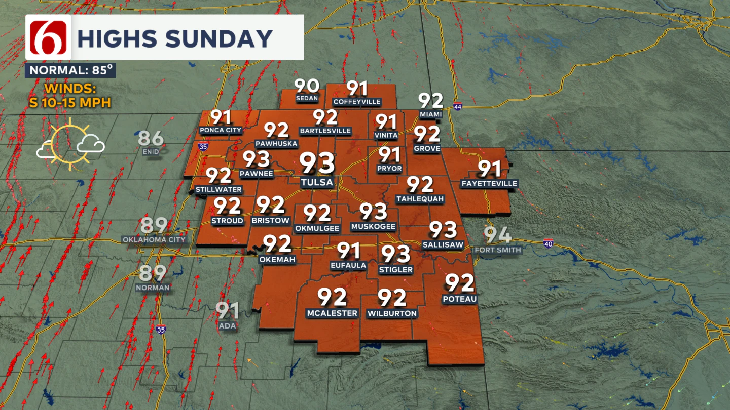
Expect more the same late summertime conditions on Sunday. High temperatures will be back in the lower 90s with a few spots reaching the mid 90s. Humidity values may be just a hair lower, but it'll remain hot.

Any Rain Nearby?
By Sunday and early Monday, the ridge will shift slightly eastward as a Pacific Northwest trough sends a wave of energy through the Rockies into the Central Plains.
This will trigger some showers and thunderstorms from New Mexico into west Texas and eventually northwestern Oklahoma. Most of this activity is expected to stay west of eastern Oklahoma.
There is a slight chance that a a few isolated showers or storms could sneak into our area from later Sunday into early Monday.
When's The Next Cool-Down?
Early next week, the ridge will attempt to strengthen again, keeping stronger storm systems away from the southern Plains and maintaining a warm, humid pattern.
From Monday through Wednesday, morning lows will hover near 70 degrees, with highs in the lower to mid 90s.
By the latter half of next week, the ridge is expected to weaken as a stronger trough approaches the central and northern High Plains. This should allow another front to move from the Northern Plains into the Central Plains by Thursday or Friday.
Lake Levels
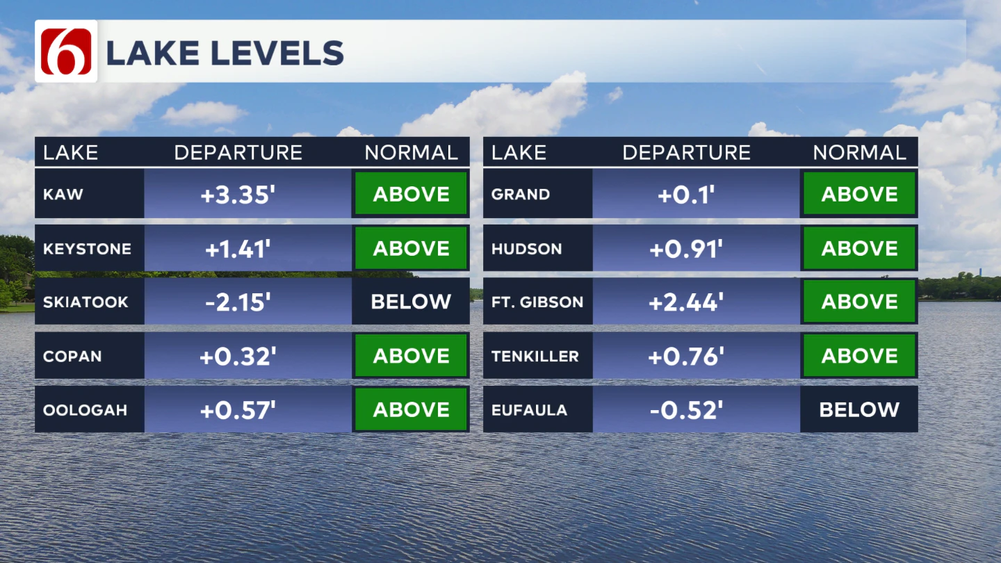
If you're making some lake recreation plans, here's an update on our area lake levels. You can look up specific lake levels anytime on our website here: https://www.newson6.com/story/5e367cbd2f69d76f6208fbb6/oklahoma-lake-levels

The Illinois River Near Tahlequah
River levels should remain around 5' give or take a little bit though the weekend.
The Morning Weather Podcast:
The daily morning weather podcast briefing will remain on hold indefinitely due to ongoing internal workflow issues.
We're working to resolve these challenges as soon as possible and appreciate your patience. We apologize for the inconvenience and hope to be back soon. Thank you for your understanding.
Hot weather safety:
🔗 Oklahoma heat safety tips: How to spot and prevent heat illness
🔗 Top summer safety tips every family needs to know
🔗 'It can happen to anybody': First responders warn of hot car deaths
Need-to-know severe Oklahoma weather prep:
🔗Severe weather safety: what you need to know to prepare
🔗Tornado Watch vs. Tornado Warning: what they mean and what to do
🔗Severe weather safety: what to do before, during, and after a storm
🔗Why registering your storm shelter in Oklahoma could save your life
🔗Floodwater kills more Oklahomans than tornadoes in the last decade, here's why
🔗'Turn around, don't drown': Flood safety tips for Oklahomans
🔗5 things to know: How Oklahomans can get federal money to install storm shelters
🔗Breaking down the SoonerSafe Rebate Program: Do I qualify for a storm shelter?
Watch us on YouTube
Follow NewsOn6 on X/Twitter for automated severe weather alert posts: @NewsOn6
Emergency Info: Outages Across Oklahoma:
Northeast Oklahoma has various power companies and electric cooperatives, many of which have overlapping areas of coverage. Below is a link to various outage maps.
- PSO Outage Map
- OG&E Outage Map
- VVEC Outage Map
- Indian Electric Cooperative (IEC) Outage Map
- Oklahoma Association of Electric Cooperatives Outage Map — (Note: Several Smaller Co-ops Included)