Tulsa Weather: Scattered storms possible

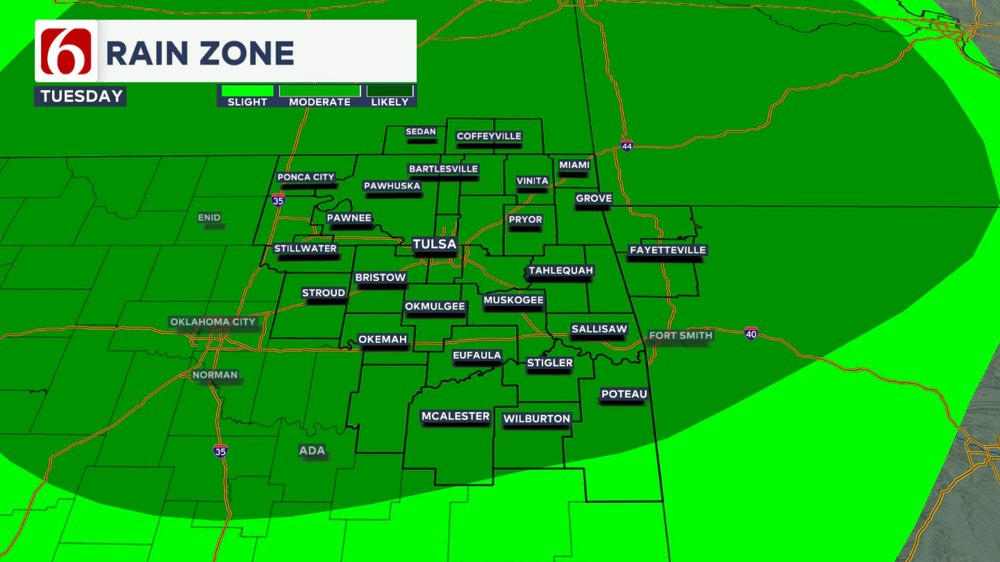
By Tuesday morning, a weak boundary should be just north of the immediate area. The upper air flow from the northwest is likely to foster a disturbance moving across the central plains that will produce at least a small cluster of storms Tuesday morning.
This small complex is likely to move southward, approaching southeastern Kansas and northern OK on Tuesday from midday to afternoon. A 40% probability of storms will be in the forecast for most locations.

With high atmospheric moisture, heavy rainfall will be likely in some spots, which could lead to localized flooding. Damaging downbursts of wind will be possible.

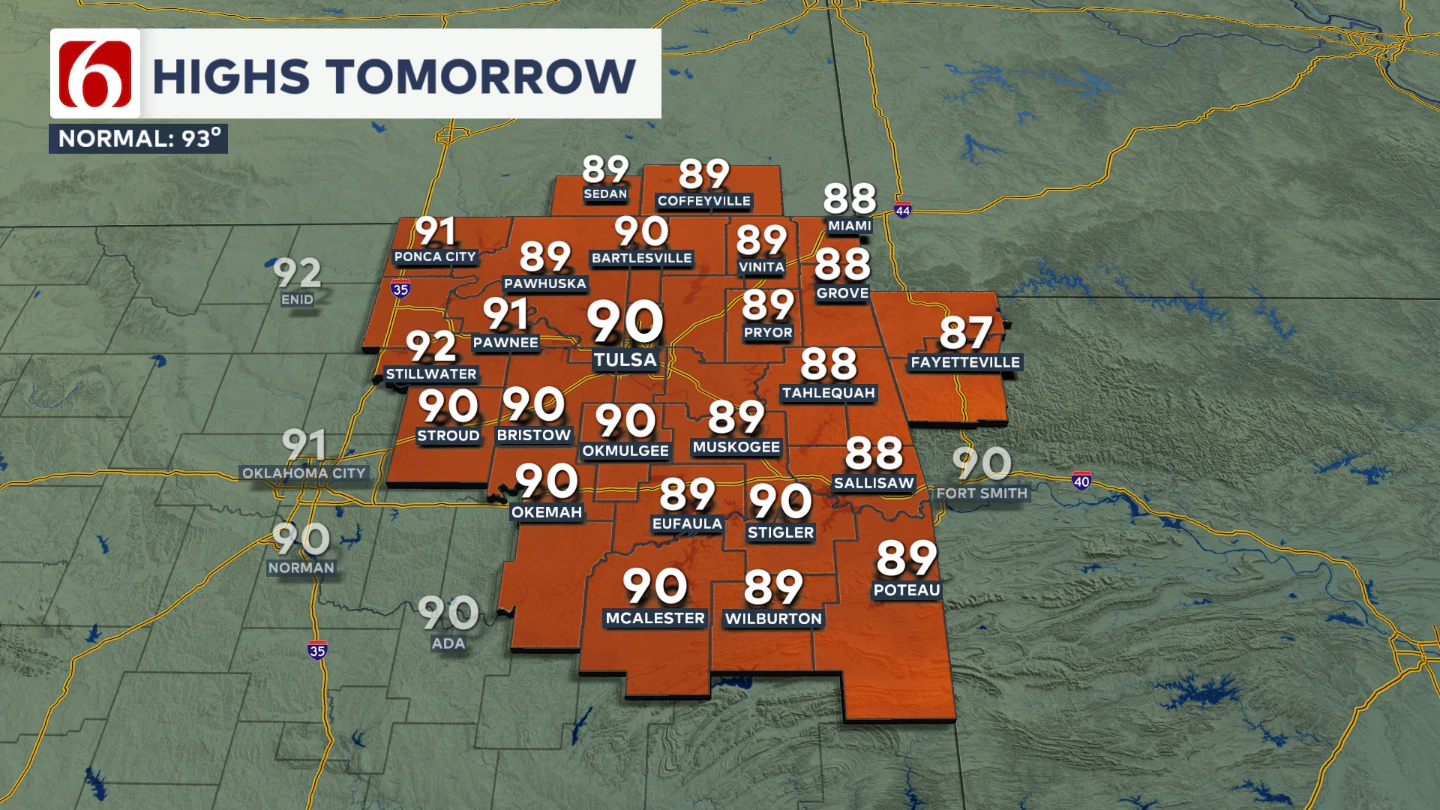
Despite the increasing storm chances, Tuesday afternoon highs should still reach into the upper 80s and lower 90s with heat index values nearing the upper 90s.
Wednesday
On Wednesday, the upper-level flow will continue from the west to northwest and may carry a disturbance from the Rockies into the central Plains that could influence part of the area late Wednesday night or early Thursday morning across far northeastern Oklahoma.
For this forecast cycle, storm probabilities will remain relatively low Wednesday with afternoon highs in the lower 90s.
Thursday and Friday: Heat Stress Concerns
Thursday and Friday, a mid-level ridge of high pressure will become the dominant weather feature, likely to suppress organized storm activity for a brief period.
A southerly surface flow, paired with increased evapotranspiration, will boost low-level moisture and push dew points into the mid to upper 70s.
With afternoon highs climbing into the lower to mid-90s, heat index values may reach advisory levels, potentially ranging from 102 to 107 degrees.
Weekend Outlook: Storm Chances Return
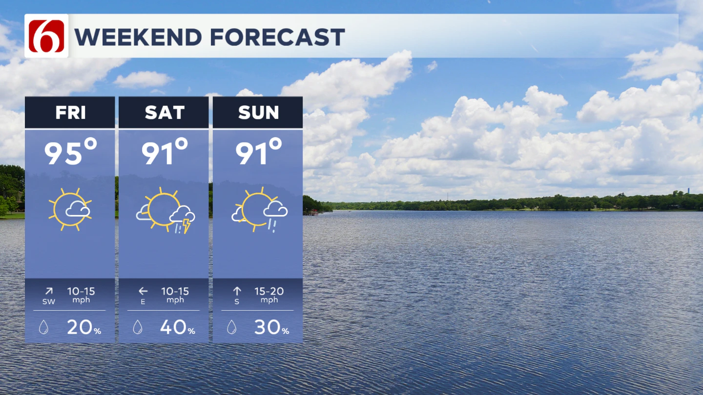
By the weekend, the ridge is expected to weaken as another weak boundary approaches the central Plains. Westerly to northwesterly the upper flow will return and will bring renewed storm chances across the state.

While timing and exact probabilities remain uncertain, there will likely be at least a low to moderate risk for storms this weekend. Be sure to check back for forecast updates as confidence improves in the coming days.
Recreational Impacts
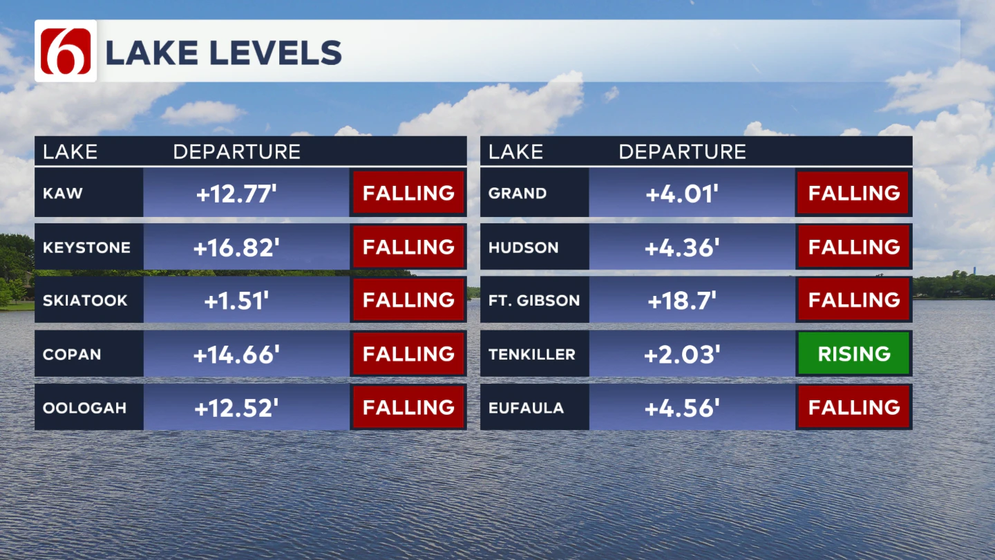
Area lake levels remain elevated, which could impact some recreational areas. Many lakes also have floating debris. Use extra caution on the water. Levels are slowly dropping, but will remain high for the upcoming week.

The Morning Weather Podcast:
The daily morning weather podcast briefing will remain on hold indefinitely due to ongoing internal workflow issues.
We're working to resolve these challenges as soon as possible and appreciate your patience. We apologize for the inconvenience and hope to be back soon. Thank you for your understanding.
Hot weather safety:
🔗Oklahoma heat safety tips: How to spot and prevent heat illness
🔗 Top summer safety tips every family needs to know
🔗 Swimming pools, splash pads & aquatic centers in Tulsa metro to stay cool
Need-to-know severe Oklahoma weather prep:
🔗Severe weather safety: what you need to know to prepare
🔗Tornado Watch vs. Tornado Warning: what they mean and what to do
🔗Severe weather safety: what to do before, during, and after a storm
🔗Why registering your storm shelter in Oklahoma could save your life
🔗Floodwater kills more Oklahomans than tornadoes in the last decade, here's why
🔗'Turn around, don't drown': Flood safety tips for Oklahomans
🔗5 things to know: How Oklahomans can get federal money to install storm shelters
🔗Breaking down the SoonerSafe Rebate Program: Do I qualify for a storm shelter?
Watch us on YouTube
Follow NewsOn6 on X/Twitter for automated severe weather alert posts: @NewsOn6
Emergency Info: Outages Across Oklahoma:
Northeast Oklahoma has various power companies and electric cooperatives, many of which have overlapping areas of coverage. Below is a link to various outage maps.
- PSO Outage Map
- OG&E Outage Map
- VVEC Outage Map
- Indian Electric Cooperative (IEC) Outage Map
- Oklahoma Association of Electric Cooperatives Outage Map — (Note: Several Smaller Co-ops Included)